I got off the bike to check whether it was safe for the bikes to pass through. The downward slope was muddy. I trod carefully until I reached the point where the landslide had occurred. It appeared to be quite recent. Crossing the road, the debris had made it to the river flowing alongside it. Thankfully, two JCBs had been working on clearing a path. I gave the heads-up to my friends and waited.
I was far from home, in the midst of an unexplored land. All I had said to my parents before leaving was that I was going to Guwahati and that I had a friend there. I wasn’t exactly lying. I did have a friend in Guwahati. And I would go there, eventually. I just didn’t tell my parents the route I was going to take to reach there.
Located 70 kilometers away from the city of Gangtok, Dzongu had been established as an official reserve for Lepchas, the original inhabitants of Sikkim. No travel agent covered this place in his itinerary; they even advised against it when enquired about. The reason behind it was that the countryside was infested with rugged roads, frequent landslides and offbeat tracks. Possibly, it was the same reason why my friend – quite frequently referred to as Google Marley – had been so intent on bringing us here, that too on bikes.
Out of the four of us, Travels-a-lot was the only one who had been a part of long bike trips before, having journeyed to Leh, Ladakh and Spiti. Then there was Marley himself, who although inexperienced, was blessed with Lady Luck sitting on his shoulder. The speed of his bike didn’t vary with the terrain or the condition of the road. To him, the brakes on the bike were just for display. Only Oldie McWisey was capable of keeping him in check, as he constantly did, haranguing him from the back seat.
Not comfortable with the driving part, I had picked up the mantle of being the navigator as well as the photographer of the group. I had downloaded the entire map of Sikkim because there was little or no network coverage in the hilly areas. Thanks to the efficient battery backup of my cell phone, I had piloted the four of us all the way from Siliguri. Though, ambiguities arose at times when the map showed two different routes or the road that was clearly visible up ahead didn’t show on the map. It was suggested then by Oldie McWisey that we should consult the locals too.
“Which way to Tingbong,” I asked one of the locals when one such ambiguity stared into my face again. The river valley had suddenly widened, narrowing the path up ahead. The uphill road, riddled with bedrock appeared like a ledge sticking out of the mountain.
The man pointed in the reverse direction. That did not make sense as I did not recall seeing another path diverging from this one. Sensing my confusion, he explained further.
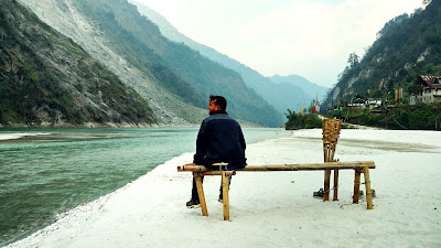
We turned our bikes around and drove until we reached the point where the river valley had begun to expand. There were tire marks leading downward and then continuing on the dry sand by the river. In the distance, where the tracks ended, I could see a bridge leading across the river. That was it. McWisey and I got down while Travels-a-lot and Google Marley manoeuvred the bikes through the sand until they found a firm ground to park the bikes.
It was a sight to behold.
The river must have shifted its course long back, restricting itself to one side thereby creating a sandy beach surrounded by mountains. I no longer felt the fatigue of the journey. All of it was washed away by the surreal beauty and the peace and calm this place offered.
“Told you it would be worth it,” Google Marley announced to all of us.
“Yeah whatever,” replied Oldie McWisey.
While I had my moment, I let Marley have his. Being the official trip planner for all intents and purposes, he had been receiving a lot of ire whenever something went wrong on the trip. When Travels-a-lot patted him on the back, I could almost see him blush.
Not that I wanted to, but we left soon. Evening was setting in. And if the road up ahead was just as treacherous as the stretch we had covered so far, we needed to hurry.
***

Comments
Post a Comment